Showing posts with label trip reports. Show all posts

Monday, May 11, 2015

Fort Cronkhite Loop Trail, Marin Headlands

Rodeo Lagoon is one of my favorite spots on the central California coast. This past February, we took advantage of some remarkably dry weather to hit the trails in the Marin Headlands. It was Super Bowl Sunday and we enjoyed a late afternoon ridge hike and practically had the place to ourselves!

Here is a nice view of the Wolf Ridge high above Fort Chronkhite from the parking lot at Rodeo Beach. We took a 5.2 mile loop hike which traverses a portion of the ridge.


The hike starts at Rodeo Beach, one of my favorite spots in the Marin Headlands.


A few surfers jockeyed for waves at the north end of the beach. The surf was pretty calm and it looked like a nice day to be out in the water.


A couple hundred feet up the trail you can look back down on the lagoon and beach. This is one of my favorite views in the bay area. I don't know why - it just is.


After a few more minutes of hiking, we came upon the Battery Townsley, constructed in 1938. Park Service volunteers were conducting tours and a very friendly lady gave us the last tour of the day through the tunnels buried in the hillside. During WWII, this entire installation would have been carefully camouflaged to hide it from spying eyes.


A little bit higher up the ridge we got an even better view of the beach, looking over towards Point Bonita, with San Francisco in the background. Sutro Tower is visible on the ridge in the background (in my neighborhood!), with the hills around Pacifica (Montara Mountain and Point San Pedro) stretching out to the south.


This is the site of the massive 68-foot long artillery gun mounted in the hillside at Battery Townsley. With a range of 25 miles, the idea was that you could triangulate on an enemy warship, project its speed and trajectory, and hit the target within three shots. Seems kind of improbable to me, but the Park Service volunteer assured us that the crew was quite capable.


Here's a photo of a gun similar to that mounted at Battery Townsley.


We saw a few folks up on the trail but we mostly had the ridge to ourselves since it was close to sunset. This is the view looking north towards Tennessee Valley.


There is a paved trail at the top of the ridge that takes you up to Hill 88 (elevation 988 ft), which has a history as a radar site for nearby Nike missile installations.


There are quite a few abandoned buildings at the top of the hill. This one provides a view of Ocean Beach in San Francisco, through the window.


Once on top of the ridge, we found sweeping views of the Pacific Ocean to our west.


Looking west along the ridge at sunset. It was a beautiful day to be up in the Marin Headlands.


This is the view coming down from Hill 88. You have to backtrack just a little bit to pick up the rest of the Wolf Ridge trail, which drops down on the backside of the ridge and then joins the Miwok trail to loop back around to Rodeo Lagoon.


We got a late start and took an unexpected tour of Battery Townsley so we ended up hiking down the road back to the car in the dark. It was worth it though!


Sunday, November 23, 2014

November afternoon at Ocean Beach - first video

On Saturday afternoon I headed out to Ocean Beach to practice using the video functionality of my Nikon D7100. It was sunny at my house on the Panhandle but by the time I got out to the Inner Sunset it was grey and misting! I thought I saw clearing clouds to the west and sure enough by the time I got to the Great Highway it was sunny and warm, although a bit windy. The storms clouds were headed eastward and I was in for a perfect fall afternoon at the beach.

I opened my trunk to get my camera and tripod only to discover I was missing the plate that attaches the camera to the tripod! Ahhh! I guess my first video attempt was destined to be a shaky hand-held operation.

I had been experimenting with the video settings the night before and had the camera in monochrome mode. I turned the camera on and liked what I saw and the black and white colors seemed appropriate for a post-storm November outing so I left the settings as is.

I left the camera in aperture-priority mode and for the most part the camera behaved like I wanted. The focuses proved to be the trickiest aspect because it was hard to see the live display on the back of the camera due to the glare so I couldn't always tell if the image was in focus.

I tried to follow some guidance I had read online of shooting a few 10-second clips and then editing them together at the end. I tried to vary the shots - some landscape, some details, some personal.

When I got home I still didn't have a viable option for the video editor! I did a little research online and downloaded the Microsoft Movie Maker, which proved to be just the right balance of simplicity and functionality for me to stitch together the clips, add transitions, and overlay a soundtrack.

Hope you enjoy!


Ocean Beach from California Beach Blog on Vimeo.

Monday, August 11, 2014

Exploring the Devil's Slide Coastal Trail

After driving the narrow coastal road along Devil's Slide for years, I was very excited for the opening of the bypass tunnels in 2013. Construction of the tunnels was a major victory for environmentalists who had opposed construction of an inland route over Montara Mountain since the late 1950s. In addition to celebrating the opening of the tunnels, we can also celebrate the opening of a new coastal access trail which runs for 1.3 miles along the old HWY 1. The Devil's Slide trail is also part of the statewide California Coastal Trail. We visited the new trail in June 2014.

The northern entrance to the Tom Lantos Tunnels, completed in 2013.
We started our hike from the Pacifica side of the tunnels. The parking area is relatively small and we secured the last open spot (there is more parking available at the south end of the tunnels). There is a bathroom and water fountain at the start of the path, which slowly climbs upwards for about a quarter mile. The path accommodates both pedestrian and bike traffic.
The northern start to the Devil's Slide Coastal Trail.

We saw these interesting looking plants all along the first section of the trail. I believe they are called Pride of Medeira and are fairly common along the central coastal areas of California.
Pride of Medeira flowers along the trail.

We soon came upon a nice landscaped overlook with expansive views across the Pacific. It was a little hazy but I bet on some days you can spot the Farallon Islands in the distance.


To the north we could see the rocks of Point San Pedro and the San Andreas fault line far in the distance. I believe the terraced bench seen running along the cliff in this photo is the old Ocean Shore Railroad grade. The railroad was originally planned to extend 73 miles from San Francisco to Santa Cruz; however, the 1906 earthquake caused extensive destruction and delays. The tracks were never completed and the Ocean Shore Railroad went bankrupt in 1921.

Point San Pedro visible to the north from the trail.

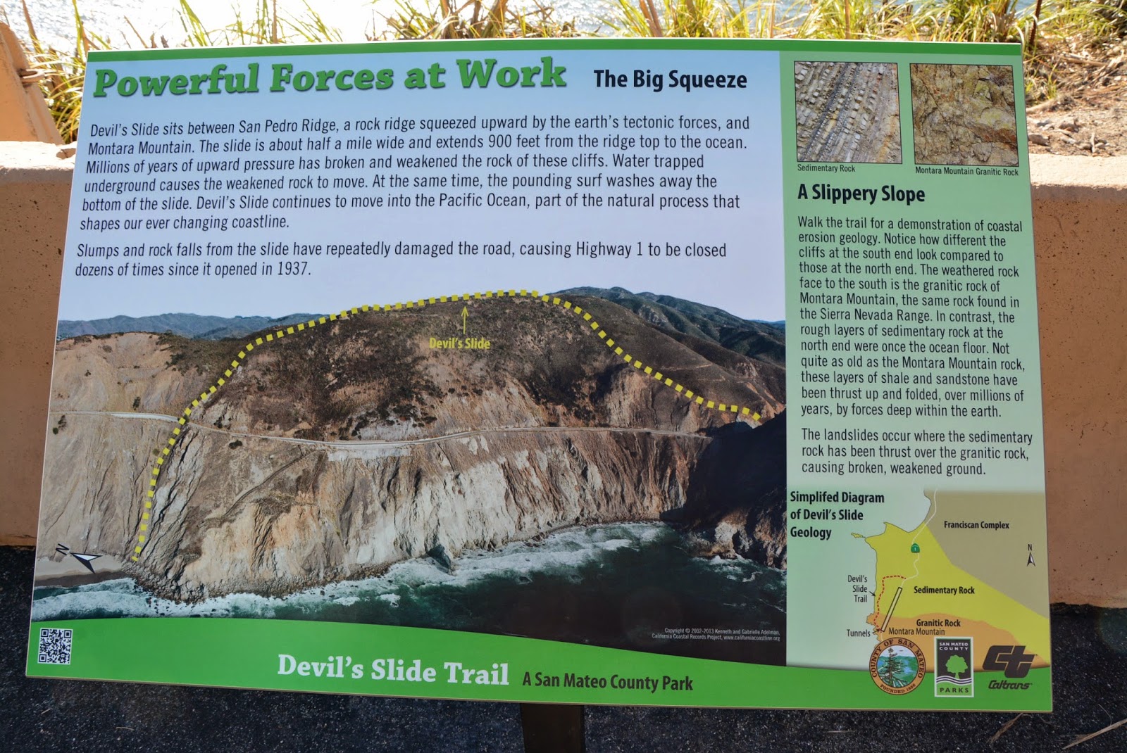
This stretch of coastline between Point San Pedro and Montara Beach is well known for its unstable geology and steep coastal cliffs. Waves erode the base of the bluffs which makes them susceptible to landslides.


The northern half of the area consists of deformed and fractured sandstones and shales which are prone to rockfall and slides (Griggs et al. 2005). The unstable rocks can be seen perched above the roadway.

Unstable sandstone and shale above the roadway.

The bedded layers of sandstone and shale rock are easily visible along the roadside. A geologist's dream! These rocks were formed during the Paleocene, approximately 60 million years ago.


Barriers along the road help keep rocks from falling down onto the path. It's hard to believe the state was able to maintain this section of road for so long!


In addition to the barriers on the road, the state has constructed an extensive system of slope stabilization and drainage to lower groundwater levels over the past decades to help secure the slope.

Slope stabilization measures along the Devil's Slide coastal trail.

As you make your way to the south towards Montara, the rock transitions to deeply weathered but more stable granitic rocks (also known as Montara granodiorite). These granitic rocks are similar to the granite outcrops at Bodega Head and Point Reyes, which have been transported northward on the Pacific Plate from their place of origin in southern California (Hayes and Michel 2010).

Drainage pipes are part of the state's efforts to stabilize the slope. A former WWII military emplacement to spot enemy ships is visible on the hilltop in the distance.

This photo from the California Coastal Records Project (californiacoastline.org) shows the precarious HWY 1 along Devil's Slide running high above the Pacific Ocean. Various drain pipes and slope stabilization measures are visible in the photo.

HWY 1 along Devil's Slide. Source: California Coastal Records Project.

As we continued, the views did not fail to impress and there were abundant wildflowers along the ridge below the trail.


At two locations along Devil's Slide, old military emplacements can be seen keeping watch over the Pacific. Eight-one stations were built along this stretch of coast from Point Reyes to Half Moon Bay between 1892 and 1949 to spot and triangulate the positions of enemy ships off our shores.


At the far south end of the trail, a view of Montara Beach emerges. Montara Beach is a wonderful unique beach definitely worth a visit!

View of Montara Beach to the south from the Devil's Slide Coastal Trail.

Until next time... Keep exploring!

Sunday, February 2, 2014

To the edge of the Pacific Plate at Tomales Point

After seven years in the Bay Area, Allison and I finally made the trip out to Tomales Point, the long sliver of land separating Tomales Bay and the Pacific Ocean. What makes this location particularly unique is that it represents the tectonic boundary between the North American Plate (on the east side of Tomales Bay) and the Pacific Plate (on the west side of Tomales Bay). This chunk of land has moved northward approximately 90 miles over the last 50 to 60 million years, although its origins trace back even further to the Tehachapi Mountains in southern California.

Tomales Point is the northernmost point in Point Reyes National Seashore (photo source: California Coastal Records Project). The trail takes you all the way to the edge of the Point.

The hike starts at the end of Pierce Point Road at the Tomales Point Trailhead and continues approximately 4.5 miles out to the northern end of the point. The peninsula is flanked by water on three sides.


According to the National Park Service website, the Pierce Point Ranch was established in 1858 and was one of the most successful dairies of its time. The trail winds around the old ranch site before setting out for the ridge.

The old milking barn at Pierce Point Ranch.

The old milking barn at Pierce Point Ranch. Cows with a view!

We arrived around 1pm on a Saturday and the parking area was quite full. We encountered quite a few hikers on their return trip, but saw fewer and fewer as the day went on.

And we're off! The Tomales Point Trailhead.

A short distance along the trail we were greeted by sweeping views of the rocky cliffs on the Pacific side of the point.

The rocky cliffs of Tomales Point, with Bodega Head in the background.

On the other side of the peninsula, Tomales Bay was a little harder to see because the trail doesn't follow the high point of the ridge, but we were able to catch a few views to the east, including glimpses of Hog Island out in the middle of the bay.

View across Tomales Bay with Hog Island in the middle

For such a long hike, the trip was relatively moderate as the trail follows the flat plateau of the point. There are a few sections of up and down but overall nothing too steep.


After a couple miles we caught our first glimpse of the Tule Elk known to inhabit the area. I used my telephoto lens to snap a few pictures from afar. Little did we know, the elk would soon appear immediately adjacent to the trail, a little too close for comfort!


By the 1870s, the Tule Elk were all but extinct in California, supposedly reduced to a single breeding pair. Today, their population numbers in the thousands. These guys were trying to hide but we still managed to spot them somehow...


Some of the elk seemed to be quite nervous around us, while others paid no attention. The grass was so dry from the drought, I'm not sure what was left for these guys to eat!

Tule elk grazing with Tomales Bay in the background.

We continued out towards the point. The trail deteriorates a little bit and turns into a relatively easy to follow sandy path for the last half mile. This section of the hike was very exposed to the wind due to its northwest orientation.

View looking out to the end of Tomales Point, with Bodega Head in the distance.


At the end of the trail you can scramble down a little bit to the very edge of the cliff. To the north across Bodega Bay is Bodega Harbor, which is visible as a depression in the horizon caused by the San Andreas Fault. The bedrock outcrop at the base of the point appeared to be more erosion-resistant granitic rock with more erodible sandstone making up the upper receding portion of the bluff.

The edge of Tomales Point, with Bodega Head visible in the distance.

After a quick break for snacks we packed it up and headed back up the ridge. By this time, we were two of only a handful of folks still left on the trail. The elk seized upon the opportunity to take over the trail and blocked our path out!

Attempting to bypass the elk by traveling cross country just west of the main trail.

We skirted around to the side of the elk and made it about 100 yards before they spooked and headed off down the ridge.


 On our hike back we were treated to a stunning sunset view down the coast towards Point Reyes.

View of McClure's Beach from the Tomales Point trail on the return trip, with the Point Reyes beaches in the background.

We made it back to the car at dusk and explored the Pierce Point Ranch for a few minutes before packing up. Another successful day trip to the Point Reyes National Seashore. Tomales Point? Check!

Sunday, August 25, 2013

Kayak Camping in Tomales Bay

This past weekend a group of our friends planned a kayak camping trip to Tomales Bay. Despite daunting logistics, we managed to transport 24 kayakers the 2.5 miles from Marshall, across Tomales Bay, to Tomales Beach. We arranged to meet Saturday morning at Blue Waters Kayaking in the town of Marshall on Tomales Bay's east shore. The weather was surprisingly calm and warm despite a small craft advisory along the open coast due to offshore winds.

A calm start to the day on Tomales Bay

Once we all arrived, we packed up our stuff and completely filled the Blue Water motorboat with gear and supplies. I was worried we might sink the boat, but the boat driver was very accommodating so we loaded him down with all the essential (and non-essential) gear! In order to feel like I was pulling my own weight, we loaded our kayak with a few small bags to share the burden.

Motorboat support, courtesy of Blue Water Kayaking. This was only part of the way through the packing.

The staff pulled out our 12 kayaks and briefed us on proper kayaking technique, which apparently involves synchronized holding of the paddle over your head.

Now, hold the paddle over your head and make a right angle with your arms...

From the pier, Tomales Beach looked like a long ways away.  Just as we cast off, a light breeze picked up and produced some wind chop which we had to negotiate. I steered our boat straight across the Bay so that we could head up along the west shore with some shelter from the wind and waves.

Anne and Mike, Tomales Bay pirates, attempting to sink our kayak.

Easy going on the west side out of the wind.

We passed Marshall Beach along the way but continued onwards to Tomales Beach. I didn't time it exactly, but it seemed like it took a little over an hour to make it over to our camping spot. The combination of the wind and the incoming tide slowed us down a bit.

Success! Laying claim to Tomales Beach

Our gear and supplies were waiting for us on the beach when we arrived. We pulled the kayaks ashore above the high tide line and set up our tents, which was followed by much napping and lounging on the beach. The weather continued to improve and stayed calm the rest of the day.


We had some great weather and the sun persisted into the early evening. I grabbed my camera and took some shots. It was very peaceful and quiet. The nearest road is over a half mile away and only boat-in camping is allowed.

Small sandy point at the north end of Tomales Beach

View across the Bay

Not a bad view!

The crew played some football, frisbee, and even a game of Settlers of Catan before assembling for dinner. Tacos and burritos were on the menu, including tortillas, tomatoes, beans, avocados, onions, mushrooms, cheese, salsa, and hot sauce. Oh, and of course, soy chorizo (which tastes better than it sounds)!

Anne and Mike during the Great Mushroom/Onion Cook-off of 2013

And THAT is what soy chorizo looks like...

Allison and I went for a walk up the hill and got a nice vantage point to the cove just to the north of our beach. We saw a lone kayak heading back towards the shore just as it was getting dark.

Lone kayaker on Tomales Bay at sunset with Hog Island in the background

The weather stayed clear and although we couldn't quite see the sunset we got a nice display of clouds and fog in the evening light.


We waited until it got dark and then started the fire. Jonas had thought of just about everything and dessert consisted of pineapple skewers and smores.

Roasting pineapple skewers over the very hot fire

After some time around the fire, we were ready for the main act of the evening - bioluminescent dinoflagellates - or, glow-in-the-dark algae! Apparently during certain times of the year, these plankton are concentrated in the shallow waters of Tomales Bay. As we paddled out into the darkness we saw this magic in action. The plankton produce flickers of light when they are disturbed so every paddle stroke seemed to produce hundreds of tiny sparkles in the water. We could even see the paths of fish under the boat as they darted through the eelgrass, illuminated by the plankton. It was quite an experience and definitely one of the coolest natural phenomena we had ever observed.

The next morning we awoke to a foggy wet bay as the sun tried to push through and burn off the fog.


After a breakfast of eggs, mangoes, and croissants, we packed up our gear and readied the boats for the paddle back.

Mike and Sam getting ready for the paddle back to Marshall


Low tide shoreline along Tomales Beach


With the wind at our backs (and improved paddling technique) we made short work of the paddle back, covering the 2.5 miles in under an hour. After a short wait back in Marshall, the motorboat arrived with our gear and we were on our way! We headed north along Highway 1 and spotted Tomales Beach across the Bay.

Tomales Beach viewed from Highway 1 across the Bay

It was just about lunchtime so we headed inland to Santa Rosa and hit up the Russian River brewery. A fine way to end the weekend!