Showing posts with label photography. Show all posts

Thursday, October 22, 2015

West vs. East Coast Beaches: The best of both worlds

Today's blog post was written by guest blogger, Donna Fitzgerald, of Wilmington, NC. Donna has lived in Wilmington for 7 years and enjoys taking visits to the beach with her two daughters. Donna is an avid reader and writer- what better place to compose than on the sandy shores!

Thanks, Donna, for researching this topic and sharing with the Beach Blog!

The beaches throughout the United States all offer some varying levels of beauty. Many will argue which area of the country contains the best beaches. For some, it's the surfing conditions that make a beach the best. For others, the beach terrain and weather conditions may make one coast more favorable than another.

There are many differences between the coastal beaches of California and the shoreline of North Carolina. Some differences are notable and evident to the average beach-goer. Other aspects are less obvious and require research and understanding of the varying geographic areas.

Sandy beaches and dunes are typical along the Outer Banks of North Carolina.

Physical Differences

The coast of North Carolina is mostly made up of barrier island chains that allow visitors to travel over many bridges to get from one island to the next. One of the most famous areas, the Outer Banks, is completely made up of thin island chains and sandy beaches separated from the mainland by large shallow bays. The coast of western beaches - California in particular - contains mostly beaches that are immediately adjacent to the mainland areas. Barrier islands and inlets are few and far between.

As we all know, the coast of California is under constant watch for tectonic activity. The east coast is what is referred to as a passive margin, while the California coast is on an active margin. With this being said, California is much more prone to earthquakes and unpredictable tectonic shifts.

Climate

The eastern shores of the United States are much more prone to experiencing tropical cyclones that form off the Atlantic. With these storms comes the risk of tropical depressions, tropical storms, and hurricanes that can impact the coast. With this being said, the climate in each area varies greatly. In general, the beaches of the Pacific Northwest (northern California, Oregon, and Washington) receive the highest amounts of precipitation. East coast beaches receive moderate precipitation and central and southern California beaches receive the least. El Niño cycles can greatly affect the distribution of precipitation along the west coast.

The waves roll in at Pacific State Beach, about 15 miles south of San Francisco.

Other Differences

Sandy beaches mostly make up the shorelines of east coast beaches. To the north, you may find a few New England beaches that feature rocky, jagged shorelines. The east coast primarily features sandy shores that make beach time more enjoyable and relaxing for visitors.

The west coast beaches, like those along the coast of California often feature rocky terrain and steep slopes. The California shoreline often contains many more steep hills and cliffs, like those along Big Sur in central California. These can pose threats to visitors and special cautions should be exercised.

One of the biggest advantages of west coast beaches in comparison to the east coast beaches is the consistent wave climate. California beaches are known for having higher, longer period waves due to the offshore wave climate and narrower continental shelf along the west coast. Surfing conditions are more ideal on the west coast compared to the east coast, where waves are less consistent. This being said, great east coast surfing spots can be found.

Steep beaches with waves make for fun skimboarding at Montara State Beach, about 30 miles south of San Francisco.

Visitors

If you are visiting either coast, be sure to take note of these unique differences. Some tend to favor visiting the east coast beaches because of their sandy shorelines and enjoyable temperatures. Others believe California and west coast beaches are better to visit because of their geographic diversity and great surfing conditions.

Which coast do you prefer?

Sunset near Cape Hatteras, on the Outer Banks of North Carolina.


Monday, May 11, 2015

Fort Cronkhite Loop Trail, Marin Headlands

Rodeo Lagoon is one of my favorite spots on the central California coast. This past February, we took advantage of some remarkably dry weather to hit the trails in the Marin Headlands. It was Super Bowl Sunday and we enjoyed a late afternoon ridge hike and practically had the place to ourselves!

Here is a nice view of the Wolf Ridge high above Fort Chronkhite from the parking lot at Rodeo Beach. We took a 5.2 mile loop hike which traverses a portion of the ridge.


The hike starts at Rodeo Beach, one of my favorite spots in the Marin Headlands.


A few surfers jockeyed for waves at the north end of the beach. The surf was pretty calm and it looked like a nice day to be out in the water.


A couple hundred feet up the trail you can look back down on the lagoon and beach. This is one of my favorite views in the bay area. I don't know why - it just is.


After a few more minutes of hiking, we came upon the Battery Townsley, constructed in 1938. Park Service volunteers were conducting tours and a very friendly lady gave us the last tour of the day through the tunnels buried in the hillside. During WWII, this entire installation would have been carefully camouflaged to hide it from spying eyes.


A little bit higher up the ridge we got an even better view of the beach, looking over towards Point Bonita, with San Francisco in the background. Sutro Tower is visible on the ridge in the background (in my neighborhood!), with the hills around Pacifica (Montara Mountain and Point San Pedro) stretching out to the south.


This is the site of the massive 68-foot long artillery gun mounted in the hillside at Battery Townsley. With a range of 25 miles, the idea was that you could triangulate on an enemy warship, project its speed and trajectory, and hit the target within three shots. Seems kind of improbable to me, but the Park Service volunteer assured us that the crew was quite capable.


Here's a photo of a gun similar to that mounted at Battery Townsley.


We saw a few folks up on the trail but we mostly had the ridge to ourselves since it was close to sunset. This is the view looking north towards Tennessee Valley.


There is a paved trail at the top of the ridge that takes you up to Hill 88 (elevation 988 ft), which has a history as a radar site for nearby Nike missile installations.


There are quite a few abandoned buildings at the top of the hill. This one provides a view of Ocean Beach in San Francisco, through the window.


Once on top of the ridge, we found sweeping views of the Pacific Ocean to our west.


Looking west along the ridge at sunset. It was a beautiful day to be up in the Marin Headlands.


This is the view coming down from Hill 88. You have to backtrack just a little bit to pick up the rest of the Wolf Ridge trail, which drops down on the backside of the ridge and then joins the Miwok trail to loop back around to Rodeo Lagoon.


We got a late start and took an unexpected tour of Battery Townsley so we ended up hiking down the road back to the car in the dark. It was worth it though!


Monday, August 11, 2014

Exploring the Devil's Slide Coastal Trail

After driving the narrow coastal road along Devil's Slide for years, I was very excited for the opening of the bypass tunnels in 2013. Construction of the tunnels was a major victory for environmentalists who had opposed construction of an inland route over Montara Mountain since the late 1950s. In addition to celebrating the opening of the tunnels, we can also celebrate the opening of a new coastal access trail which runs for 1.3 miles along the old HWY 1. The Devil's Slide trail is also part of the statewide California Coastal Trail. We visited the new trail in June 2014.

The northern entrance to the Tom Lantos Tunnels, completed in 2013.
We started our hike from the Pacifica side of the tunnels. The parking area is relatively small and we secured the last open spot (there is more parking available at the south end of the tunnels). There is a bathroom and water fountain at the start of the path, which slowly climbs upwards for about a quarter mile. The path accommodates both pedestrian and bike traffic.
The northern start to the Devil's Slide Coastal Trail.

We saw these interesting looking plants all along the first section of the trail. I believe they are called Pride of Medeira and are fairly common along the central coastal areas of California.
Pride of Medeira flowers along the trail.

We soon came upon a nice landscaped overlook with expansive views across the Pacific. It was a little hazy but I bet on some days you can spot the Farallon Islands in the distance.


To the north we could see the rocks of Point San Pedro and the San Andreas fault line far in the distance. I believe the terraced bench seen running along the cliff in this photo is the old Ocean Shore Railroad grade. The railroad was originally planned to extend 73 miles from San Francisco to Santa Cruz; however, the 1906 earthquake caused extensive destruction and delays. The tracks were never completed and the Ocean Shore Railroad went bankrupt in 1921.

Point San Pedro visible to the north from the trail.

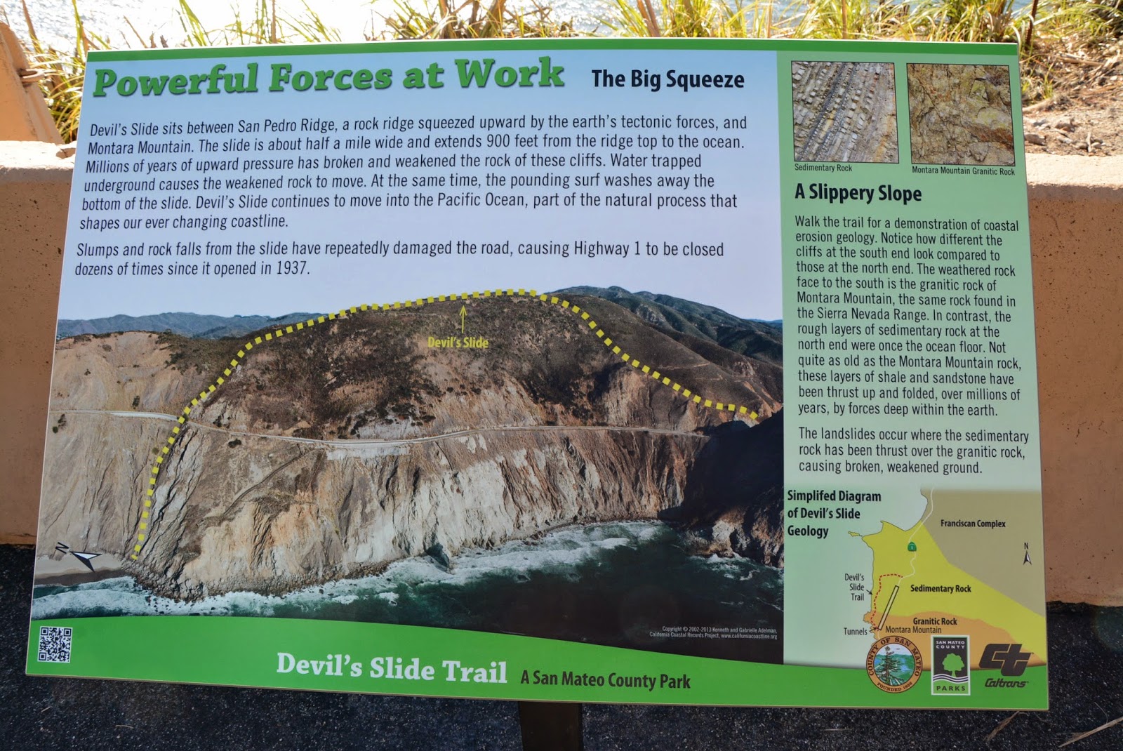
This stretch of coastline between Point San Pedro and Montara Beach is well known for its unstable geology and steep coastal cliffs. Waves erode the base of the bluffs which makes them susceptible to landslides.


The northern half of the area consists of deformed and fractured sandstones and shales which are prone to rockfall and slides (Griggs et al. 2005). The unstable rocks can be seen perched above the roadway.

Unstable sandstone and shale above the roadway.

The bedded layers of sandstone and shale rock are easily visible along the roadside. A geologist's dream! These rocks were formed during the Paleocene, approximately 60 million years ago.


Barriers along the road help keep rocks from falling down onto the path. It's hard to believe the state was able to maintain this section of road for so long!


In addition to the barriers on the road, the state has constructed an extensive system of slope stabilization and drainage to lower groundwater levels over the past decades to help secure the slope.

Slope stabilization measures along the Devil's Slide coastal trail.

As you make your way to the south towards Montara, the rock transitions to deeply weathered but more stable granitic rocks (also known as Montara granodiorite). These granitic rocks are similar to the granite outcrops at Bodega Head and Point Reyes, which have been transported northward on the Pacific Plate from their place of origin in southern California (Hayes and Michel 2010).

Drainage pipes are part of the state's efforts to stabilize the slope. A former WWII military emplacement to spot enemy ships is visible on the hilltop in the distance.

This photo from the California Coastal Records Project (californiacoastline.org) shows the precarious HWY 1 along Devil's Slide running high above the Pacific Ocean. Various drain pipes and slope stabilization measures are visible in the photo.

HWY 1 along Devil's Slide. Source: California Coastal Records Project.

As we continued, the views did not fail to impress and there were abundant wildflowers along the ridge below the trail.


At two locations along Devil's Slide, old military emplacements can be seen keeping watch over the Pacific. Eight-one stations were built along this stretch of coast from Point Reyes to Half Moon Bay between 1892 and 1949 to spot and triangulate the positions of enemy ships off our shores.


At the far south end of the trail, a view of Montara Beach emerges. Montara Beach is a wonderful unique beach definitely worth a visit!

View of Montara Beach to the south from the Devil's Slide Coastal Trail.

Until next time... Keep exploring!

Wednesday, April 16, 2014

March 1-2, 2014 Storm Round-up

Overview
California's March 1-2, 2014 storm caused quite a stir up and down the coast from the San Francisco Bay area to San Diego. According to the National Weather Service report on the event, an intense low pressure system developed off the California coast and persisted from February 26 to March 2, 2014. The system produced heavy rain, strong winds, flooding, thunderstorms, damaging winds, small hail, and high surf. Orographic lift produced large rainfall in the Santa Cruz and Santa Lucia mountains. Offshore winds reached 55 mph and peaked at 71 mph along the mountains of the Big Sur coast.Coastal impacts were mainly felt in southern California due to unusually large wave exposure. The slow movement of the low pressure system, southerly track, and strong winds created a large fetch over the open waters of the Pacific which led to large wave heights impacting the coastline in otherwise sheltered areas reminiscent of El Nino-type storms.


The low pressure system, or extratropical cyclone, developing offshore on February 28.


The wave forecast was also quite formidable, with large offshore wave heights approaching 30 feet with a westerly angle of approach, according to Surfline.

Surfline's wave forecast showing offshore wave heights approaching 30 ft with a westerly swell.


I reviewed the National Data Buoy Center offshore wave measurements over the period from March 1-2, 2014 and pulled out the peak wave conditions over that time. As you can see, the highest offshore wave heights were along the San Luis Obsipo and Santa Barbara coastlines. This is consistent with the Surfline forecast shown above which shows the maximum wave heights off of Point Conception. Also of note is the predominant westerly direction of the buoy measurements, which generally show waves approaching from the W or WSW. Once you get into the southern California bight, the offshore islands start to play a role in determining which coastal areas were hardest hit, as the islands shelter some areas more than others.

Peak Offshore Wave Heights - March 1-2, 2014

Station ID
Station
Hs (m)
Hs (ft)
Tp (sec)
Dm (deg N)
46026
San Francisco
4.0
13.1
14
238
46114
Monterey
6.5
21.3
13
246
46239
Point Sur
7.1
23.3
14
252
46028
Cape San Martin
7.4
24.3
14
244
46011
Santa Maria
7.6
24.9
15
250
46218
Harvest Buoy
6.7
22.0
17
271
46054
West Santa Barbara
6.5
21.3
15
262
46216
Goleta Point
4.3
14.1
15
261
46217
Anacapa Passage
2.9
9.5
15
267
46221
Santa Monica Bay
4.5
14.8
11.5
262
46222
San Pedro
4.7
15.4
12.3
267
46223
Dana Point
3.0
9.8
10.3
268
46224
Oceanside Offshore
3.3
10.8
17
267
46225
Torrey Pines
4.4
14.4
11.2
282
46231
Mission Bay
4.2
13.8
15
274
46232
Point Loma South
4.9
16.1
17
275

Note: Hs = significant wave height, Tp = peak wave period, and Dm = mean wave direction


I won't focus too much on the precipitation impacts, other than to note that precipitation was widespread across the state and that there was a lot of it! The NWS precipitation totals are shown below. The highest rainfall totals in central California reached 10+ inches in the Big Sur Mountains and parts of southern California.


County Summaries
Santa Cruz
Santa Cruz County was the most northern county to feel significant impacts from the storm, primarily due to its southern exposure. In the City of Santa Cruz, large waves impacted the shoreline. Waves crashed up and over the breakwater at the Walton Lighthouse at the Twin Lakes harbor entrance.

Source: Central Coast Photographs

High runup was also observed from waves impacting the bluff at Lighthouse Point. The story has it this guy lost his board shortly after jumping in and had to swim back ashore.

Source: Allen Hughes Photography

Along West Cliff Drive, a 10x10 ft, 40-ft deep sinkhole opened up due to undermining by wave action on the bluff. The sidewalk was damaged due to the pressure of breaking waves forcing their way up into the cliff. One lane of traffic was closed while crews assessed the stability of the bluff.


Along the Santa Cruz Boardwalk, waves washed up onto the beach back to the seawall, but there were no reports of damage or overtopping.

Source: Sammy Garcia Photo

The Capitola waterfront, with its long history of flooding, probably saw the worst of the storm's impacts. Waves washed over the Esplanade seawall, reaching cars in the parking lot. Wave overwash combined with urban runoff to flood the downtown area businesses. Waves crashed into the deck of the restaurants at the Soquel River mouth, but business was reported to resume the next day.

Waves overtopping the Capitola Esplanade with evidence of earlier overtopping in the form of sand and debris on the sidewalk. (Source: Sabine Dukes)

Waves impacting the Venetian Hotel Condos seawall, with evidence of earlier wave overwash of the wall. (Source: Sabine Dukes)


Waves impacting the end of the Capitola Pier. (Source: Sabine Dukes)

San Luis Obispo
San Luis Obispo also experienced some dramatic wave action due to strong waves making their way around the breakwater and impacting the shoreline. At Port San Luis, waves washed over the revetment into the parking lot just north of the boat launch.


The folks at Avila Beach Paddlesports captured some great video of the wave overwash. Search "avila beach storm" on youtube for more videos.


Avila Pier was damaged and closed. Boards on the pier were lifted up from the waves during the morning high tide. Residents were quoted as saying they couldn't remember tides and waves this high.

Waves lifted up the boards along the Avila Pier, which closed during the storm. (Source: Laura Dickinson; http://www.sanluisobispo.com/)

At Pismo Beach, waves washed all the way back to the boardwalk and seawall. City personnel had to encourage folks to stay off the beach for safety reasons.
Waves inundate the beach at Pismo Beach (Source: Central Coast Pictures)
 
Santa Barbara
Santa Barbara County had some of the most dramatic stories come out of the storm event. According to the Santa Barbara harbor patrol, they experienced high tides in excess of 6 ft and waves up to 12 ft. Elsewhere, waves averaged 10-15 ft with crests up to 18 ft. At the Moby Dick restaurant on Stearns Wharf, a wave crashed through the window during breakfast:


Waves also inundated the beach surrounding the Santa Barbara Yacht Club and flooded the back beach area, depositing sand around the Yacht Club building and causing general chaos in the parking lot.


At Goleta Beach, waves crashed through the Beachside Bar and Cafe. A restaurant manager was washed out into the ocean and dislocated his shoulder (but made it back to shore!). The restaurant was flooded with seawater and the outdoor patio area was damaged. The Goleta Pier was pounded by waves and some planks were displaced. Three boats broke loose and washed ashore on the beach. The beach area was evacuated for safety reasons. News videos and photos of the storm damage suggested that water and sand washed into the parking lot.

At Goleta Beach, this sailboat washed ashore. (Source: Mike Eliason)

At Goleta Beach, waves washed up over the beach and into the lawn area. (Source: Martin Uhler; keyt.com)

At Gaviota State Beach, a 50-ft section of the pier was destroyed sometime before 830am on March 1. Waves were reported to be breaking over the top of the pier. Wave runup was reported to surge up the beach and into the parking lot and restrooms. On the beach, sand was eroded and exposed cobbles.
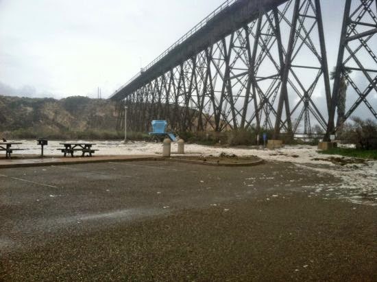
The end of the Gaviota Pier was destroyed during the storm (Source: Al Fimlaid; StandUp Paddle Sports)
Waves washed up and over the beach and into the parking lot at Gaviota State Park. (Source: Al Fimlaid; StandUp Paddle Sports)

Ventura
There were not too many reports of damage along the Ventura County shoreline. Some very large waves were documented at the Ventura Pier:

Source: Instagram (surferspointventura)
At the Point Mugu Naval Base, sand washed up and over an access roadway along Family Beach, inundating approximately 300 feet of the road along the Mugu Lagoon west spit and depositing approximately 6 inches of sand in some places.


Access road along Family Beach, Point Mugu. Source: Roberto Garcia (NAVAIR)

Orange
There were not too many reports of damage along the Orange County shoreline. At Newport Beach, a predicted tide of 6.25 ft reached 7 ft. Trucks were brought in to pump the storm drain system to keep the streets from flooding.

An oil platform offshore of Huntington Beach experienced some large waves but there were no reports of storm damage.

Huntington Beach Oil Platform (Source: Michael Latham)


Los Angeles
There was a fair amount of news out of Los Angeles in response to the storm. Large waves on the order of 8-12 ft were observed at Zuma Beach. Waves pushed past the concrete barriers along the back beach and into Parking Lot #4. Life guard towers had to be pulled back and the beach eroded 30-50 yards. In Malibu, at least one balcony stairwell was destroyed at a condo unit.

In Playa del Rey, a 200 ft bikepath was covered in a few inches of sand and debris and beach erosion was observed. The bikepath was also covered near Dockweiler State Beach.

Beach erosion at Playa del Rey (Source: Brad Graverson)

At Redondo Beach, the King Harbor Yacht Club was closed and harbor operations were interrupted on March 1. Waves on the order of 20-25 ft were reported to be hitting the breakwater. Overtopping waves created a surge in the harbor and ripped cleats off the docks and broke mooring lines. Several boats were moved to prevent breaking free from the docks. Waves washed over the wall into the parking lot. Damage was less than the January 1988 storm due to improvements to the breakwater following that storm event. 

Waves breaking over the King Harbor Breakwater in Redondo Beach (Source: http://www.brozaphoto.com/)


Surfers at Redondo Beach reported the swell to be the biggest in 31 years.


At Cabrillo Beach in San Pedro, waves rushed over the breakwater, causing significant beach erosion and sand overwash into the parking lot. In Long Beach, high surf breached a sand berm along East Ocean Blvd. Water caused minor damages in the garages and lower levels of about 20 homes between 66th and 72nd place near Alamitos Bay.
Waves impacting the San Pedro breakwater at the Port of Los Angeles (Source: http://www.michaeljusticephoto.com/)


San Diego
San Diego County also experience some flooding from the storm. At Imperial Beach, waves were 8-12 ft and sand and waves washed approximately 80 ft inland at the end of Palm Ave to the Spirit of Imperial Beach statue. Water flooded a condo garage on the north side of Cortez Street and waves were breaking offshore of the pier.

Flooding and sand deposited at the end of Palm Avenue in Imperial Beach (Source: Serge Dedina)
 
Evidence of wave overwash of the sand berm just north of the south jetty at 642 Ocean Lane apartments in Imperial Beach (Source: Serge Dedina)

In Coronado, city crews did not recall such high surf and tides in many years. Beach berms and sand stockpiles were reported to be successful in stemming the high tides. Much of the sand on the beach eroded though and sand berms needed to be replenished and rebuilt, particularly along South Beach.

If you have any photos or stories from the storm please let me know. I would love to include them in this post!