After driving the narrow coastal road along Devil's Slide for years, I was very excited for the opening of the bypass tunnels in 2013. Construction of the tunnels was a major victory for environmentalists who had opposed construction of an inland route over Montara Mountain since the late 1950s. In addition to celebrating the opening of the tunnels, we can also celebrate the opening of a new coastal access trail which runs for 1.3 miles along the old HWY 1. The Devil's Slide trail is also part of the statewide California Coastal Trail. We visited the new trail in June 2014.
 |
| The northern entrance to the Tom Lantos Tunnels, completed in 2013. |
| We started our hike from the Pacifica side of the tunnels. The parking area is relatively small and we secured the last open spot (there is more parking available at the south end of the tunnels). There is a bathroom and water fountain at the start of the path, which slowly climbs upwards for about a quarter mile. The path accommodates both pedestrian and bike traffic. |
 |
| The northern start to the Devil's Slide Coastal Trail. |
We saw these interesting looking plants all along the first section of the trail. I believe they are called Pride of Medeira and are fairly common along the central coastal areas of California.
 |
| Pride of Medeira flowers along the trail. |

To the north we could see the rocks of Point San Pedro and the San Andreas fault line far in the distance. I believe the terraced bench seen running along the cliff in this photo is the old Ocean Shore Railroad grade. The railroad was originally planned to extend 73 miles from San Francisco to Santa Cruz; however, the 1906 earthquake caused extensive destruction and delays. The tracks were never completed and the Ocean Shore Railroad went bankrupt in 1921.
 |
| Point San Pedro visible to the north from the trail. |
This stretch of coastline between Point San Pedro and Montara Beach is well known for its unstable geology and steep coastal cliffs. Waves erode the base of the bluffs which makes them susceptible to landslides.
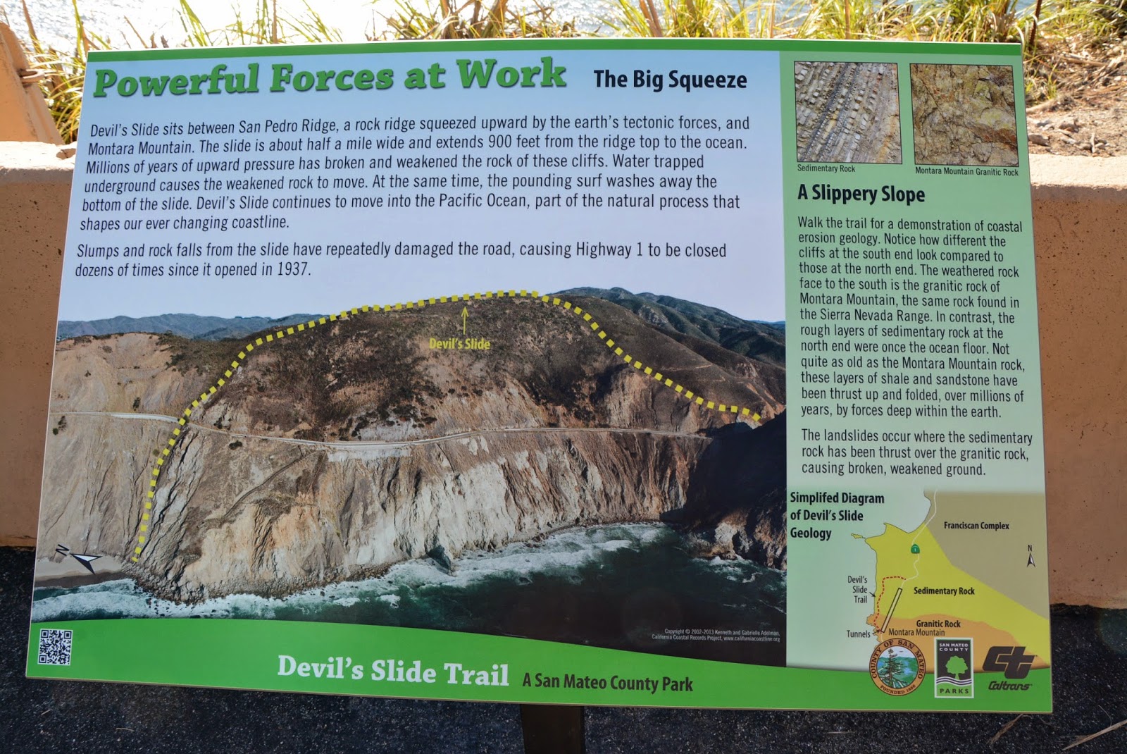
The northern half of the area consists of deformed and fractured sandstones and shales which are prone to rockfall and slides (Griggs et al. 2005). The unstable rocks can be seen perched above the roadway.
 |
| Unstable sandstone and shale above the roadway. |
The bedded layers of sandstone and shale rock are easily visible along the roadside. A geologist's dream! These rocks were formed during the Paleocene, approximately 60 million years ago.

Barriers along the road help keep rocks from falling down onto the path. It's hard to believe the state was able to maintain this section of road for so long!

In addition to the barriers on the road, the state has constructed an extensive system of slope stabilization and drainage to lower groundwater levels over the past decades to help secure the slope.
 |
| Slope stabilization measures along the Devil's Slide coastal trail. |
 |
| Drainage pipes are part of the state's efforts to stabilize the slope. A former WWII military emplacement to spot enemy ships is visible on the hilltop in the distance. |
This photo from the California Coastal Records Project (californiacoastline.org) shows the precarious HWY 1 along Devil's Slide running high above the Pacific Ocean. Various drain pipes and slope stabilization measures are visible in the photo.
 |
| HWY 1 along Devil's Slide. Source: California Coastal Records Project. |
As we continued, the views did not fail to impress and there were abundant wildflowers along the ridge below the trail.

At two locations along Devil's Slide, old military emplacements can be seen keeping watch over the Pacific. Eight-one stations were built along this stretch of coast from Point Reyes to Half Moon Bay between 1892 and 1949 to spot and triangulate the positions of enemy ships off our shores.

At the far south end of the trail, a view of Montara Beach emerges. Montara Beach is a wonderful unique beach definitely worth a visit!
 |
| View of Montara Beach to the south from the Devil's Slide Coastal Trail. |
Until next time... Keep exploring!
It us obvious from the pictures that HWY 1 never should have gone the coastal route in this area. Nature could take it back instantly.
ReplyDelete